Rescue teams search for survivors in Indonesia after powerful earthquake

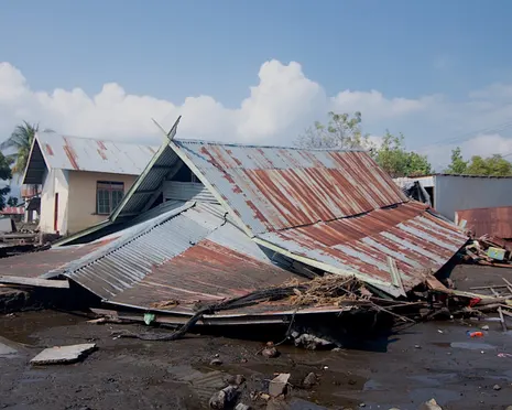
Table of Contents
Aftermath on Flores: Indonesia’s Eastern Islands Brace for Aftershocks as Rescue Efforts Intensify
Wanderstayfinder.com – The island of Flores, a narrow volcanic landmass strung along the eastern edge of Indonesia’s archipelago, was jolted by one of its most violent seismic events in recent memory. A magnitude 7.7 earthquake struck roughly 68 kilometres (42 miles) north-northwest of Ende, at a shallow depth of approximately 10 kilometres beneath the sea floor off Flores’ coast, according to the United States Geological Survey. The tremor rattled buildings across the island and was felt as far away as neighbouring West Nusa Tenggara province and portions of southern Sulawesi. Within hours, the death toll stood at at least 53, with more than 100 injured and thousands displaced from their homes.
Casualties Spread Across Six Regencies
The national disaster management agency confirmed that Manggarai regency bore the heaviest toll, with at least 24 fatalities recorded there. Neighbouring East Manggarai accounted for 17 deaths, while additional lives were lost in Sikka, Ngada, and Ende regencies. Rescue crews spent Sunday digging through piles of collapsed masonry and landslide debris across all six affected regencies, searching both for bodies and for anyone still alive beneath the rubble.
Flores is a predominantly Catholic island situated within a Muslim-majority nation, a demographic detail that shapes local community response and the role played by churches in sheltering displaced families. Landslides triggered by the quake sealed off mountain roads and buried entire hamlets, making ground access to some communities impossible for more than 24 hours after the initial shock.
Scale of Destruction
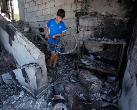
The disaster agency reported that over 900 homes were completely destroyed and nearly another 450 sustained structural damage. Approximately 5,000 residents were funnelled into temporary shelters, while thousands more chose to spend the night outdoors under open sky, unwilling to risk a second collapse during expected aftershocks. At least 167 public buildings — schools, health clinics, and churches among them — suffered varying degrees of damage.
The Trans-Flores Highway, a roughly 700-kilometre (435-mile) arterial road threading through the island’s mountainous interior and linking isolated communities to one another, was severed in multiple locations by landslide material. Restoring electricity grids, repairing telecommunications lines, and reaching remote villages cut off from all transport routes emerged as the most pressing logistical challenges facing authorities.
Voices from the Rubble
In Labuan Bajo — the coastal gateway town to Komodo National Park and one of Indonesia’s most visited tourist destinations — residents described a night of sustained terror. Anastasia Imad, a farmer who set up camp beside her damaged house in a makeshift green tent, recounted the experience:
“The shaking was terrifying, so intense that my house nearly collapsed. We feared the aftershocks would bring it down on us while we slept.”
Many of her neighbours made the same choice: sleeping under tarpaulins or in open fields rather than returning to structures whose walls had cracked or whose foundations had shifted.
Rescue Operations Resume
By Sunday, search-and-rescue teams had regained access to areas that had been unreachable since the quake struck, with particular focus on Manggarai, East Manggarai, and Nagekeo regencies. Fathur Rahman, head of the search and rescue office in Maumere — capital of Sikka regency — outlined the situation:
“We have cleared most landslides and reopened roads to previously isolated villages, although communication disruptions and power outages continue to hamper search efforts.”
Rahman added that crews were concentrating on combing through the rubble of collapsed homes and other structures for possible victims still trapped inside. Relief workers had begun distributing rice, ready-to-eat meal packs, drinking water, blankets, and basic medicines, while emergency shelter sites were being erected for families who could not return home.
A Seismic History Written in Loss
Indonesia’s position astride the Pacific “Ring of Fire” — a horseshoe-shaped belt of subduction zones, fault lines, and active volcanoes encircling the western Pacific basin — makes it one of the most seismically active nations on Earth. With more than 17,000 islands spanning three tectonic plates, the archipelago experiences earthquakes and volcanic eruptions with regularity that few other countries match.
Flores itself carries a grim catalogue of past disasters. In December 1992, a powerful earthquake followed by a tsunami claimed roughly 2,500 lives on the island. The broader region has not been spared: in September 2018, a magnitude 7.5 quake off Sulawesi generated a tsunami that killed more than 4,400 people, while the December 2004 magnitude 9.1 event off Sumatra unleashed a trans-oceanic tsunami responsible for approximately 230,000 deaths across a dozen countries.
For the communities of eastern Nusa Tenggara, each new tremor arrives not as an abstract geological event but as a reminder that the ground beneath their homes remains restless. As aftershocks continued to shake Flores through Sunday evening, residents kept watch over damaged structures, relief convoys crawled along reopened mountain roads, and the question in every village was the same: how many more nights would they spend under open sky?
Related Reading
Frequently Asked Questions
What is Rescue teams search for survivors in Indonesia?
Rescue teams search for survivors in Indonesia is the main topic of this guide. The article explains the context, practical details, and next steps readers should understand.
Why does Rescue teams search for survivors in Indonesia matter?
Rescue teams search for survivors in Indonesia matters because readers are looking for a useful answer, not just a short summary. Good content should match search intent and help them decide what to do next.