Weather Warnings as Another Tropical Storm Develops Along Gulf Coast
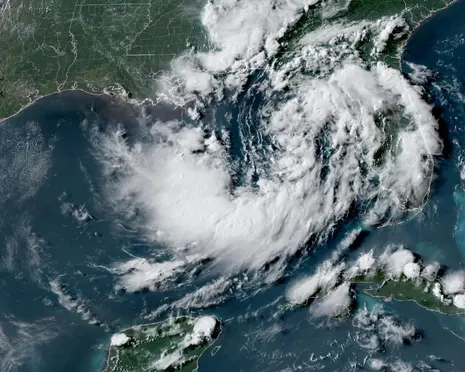
Wanderstayfinder.com – Tropical Storm Bertha developed along the US Gulf coast on Monday evening, bringing the threat of heavy rain and storm surge flooding as Tropical Storm Fausto strengthened off Mexico’s south-west Pacific coast. The center of Bertha was located about 110 miles (180 km) south of Panama City, Florida. Maximum sustained winds were around 40 mph, according to an evening advisory from the Miami-based National Hurricane Center. Residents and coastal communities are being urged to monitor conditions closely as the situation develops.
Storm Movement and Expected Landfall
The slow-moving storm has been drifting erratically, but is expected to stay near or along the northern Gulf coast early this week, bringing heavy rainfall to areas of northern Florida, Alabama, Mississippi and Louisiana as it pushes westward toward Texas. Forecasters said some additional strengthening is expected in the coming hours. Bertha is the second tropical storm of the Atlantic hurricane season and is expected to make landfall in south-east Louisiana on Wednesday. This timing could coincide with high tides, potentially amplifying flood risks in vulnerable areas.
Tropical Storm Arthur last month brought heavy rainfall to the south-eastern United States. A storm surge watch was in effect from the Alabama-Florida border westward to the mouth of the Mississippi River in Louisiana. A tropical storm watch, meanwhile, extended from the Mississippi-Alabama border to the line separating Louisiana’s Jefferson and Plaquemines parishes, the NHC added. These overlapping watches indicate that multiple hazards could occur simultaneously across the region.
The NHC said the storm surge watch indicated a risk of life-threatening coastal flooding from rising water moving inland from the shoreline within the next 48 hours.
Combined with high tide, storm surge could flood normally dry coastal areas along parts of the northern Gulf coast. Water levels could rise by 2-4ft (60-120cm) from the mouth of the Mississippi River to the Alabama-Florida border, with 1-3ft of surge possible across portions of coastal Louisiana and Florida, including Lake Pontchartrain. Emergency management officials in affected parishes have been preparing evacuation plans as precautionary measures.
The depression was also expected to produce widespread rainfall totals of 2-4in, with isolated amounts of up to 8in through Friday from western Florida to the middle Texas coast. The heavy rain could trigger flash flooding in some areas, while an isolated tornado or two was possible across Florida’s Big Bend region. Meanwhile, Tropical Storm Fausto continued to strengthen over the eastern Pacific, creating a busy period for meteorologists tracking multiple systems simultaneously.
As of Monday morning, the storm was moving west-northwest at about 13mph with maximum sustained winds of 65mph. It is forecast to become a hurricane later Monday, with additional strengthening expected over the next few days. Although no coastal watches or warnings were in effect for Fausto, the NHC said swells generated by the storm were expected to reach the west coast of the Baja California Peninsula on Wednesday and persist for several days.
The swells were likely to create life-threatening surf and rip current conditions. Fausto is forecast to continue tracking west-northwest through Wednesday. As weather warnings as another tropical system continues to develop, residents along both coasts should remain vigilant and follow local guidance from emergency management authorities.