
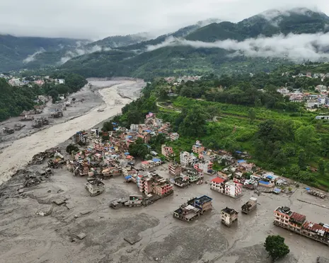
The Mountains Are Changing: India’s Himalayan Flood Risk
Wanderstayfinder.com – The mountains are changing, and the evidence arrived in a single catastrophic afternoon when a collapsing glacier on the Bhote Kashi River sent a wall of ice, rock, and sludge thundering through Nepal’s valleys. Hundreds of people were swept away or left unaccounted for, including 275 Indian nationals — a mix of hydropower project workers and pilgrims bound for Mount Kailash in Tibet. An additional 128 people of Indian origin, many affiliated with Sadhguru’s Isha Foundation spiritual organisation, were also missing. By Monday, rescue crews had recovered 149 Indian citizens, yet the toll kept climbing with each passing hour.
Back in Mumbai, Kolkata, and smaller cities between, families flooded social media with photographs, phone numbers, and desperate pleas for any trace of life among the debris. Gauri Joshi, whose five relatives had joined a pilgrim tour departing from Maharashtra, spent the weekend in a cycle of unanswered calls and television screens replaying rescue footage. What she could confirm was only that her family had cleared immigration at the Gyirong border crossing between Nepal and Tibet and boarded buses moments before the floodwaters erased the crossing entirely.
“Chances appear very bleak now. But maybe a miracle will happen,” Joshi said.
What the Cryosphere Tells Us
Glaciologists have warned for years that the mountains are changing in ways that multiply downstream danger across the Indian subcontinent. Dr Ashim Sattar, a professor at the Indian Institute of Technology Bhubaneswar who specialises in glacial lake outburst floods, broke down the layered mechanics for a wider audience. The cryosphere — every zone where water persists in solid form — contains three principal hazard components, each with its own failure pathway.
First come glacial lakes: meltwater reservoirs dammed by ice or moraine walls. When one breaches, the released volume can flatten everything downstream. Second is the glacier ice itself — the exact mechanism that tore through the Bhote Kashi valley, where a frontal tongue detached from its parent mass and triggered a debris avalanche. Third is permafrost, the frozen substrate blanketing vast stretches of the high Himalayas, which remains poorly instrumented because of the logistical difficulty of maintaining sensors at altitude.
“Everything — these lakes, glaciers and permafrost — are all hazards. Unless they’re triggered, they would not cause damage. With climate change, these grounds will go above zero degrees and will start to degrade. These would need very little … to mobilise debris. We might expect a higher frequency of debris flows in the future.”
Sattar stressed that without sustained monitoring stations and scientific investigation, no one can say how these systems are being conditioned. The Himalayan drainage networks feeding into India originate both within Indian borders and beyond them, in Nepal, Bhutan, and Tibet. Mapping every susceptible segment remains, by his account, a formidable undertaking.
Where Exposure Is Greatest
Asked which Indian states face the gravest downstream risk, Sattar offered no reassuring answer. Every Himalayan state carries hazards; the variable is timing and magnitude. In the eastern Himalayas, glacial lakes have already expanded close to their maximum extent — the full-grown lakes are approaching their limits. In the western and central ranges, retreating glaciers continue feeding new meltwater into nascent basins, leaving considerable room for further growth.
“We are still unsure when the status is going to change for any of these states. That’s a very, very difficult question, and I don’t think anyone [can] answer it at this moment without any scientific investigation.”
The direct evidence of climate impact within India’s own Himalayan sector is unambiguous: the count of glacial lakes is rising, their surface areas are expanding, stored volumes are increasing, and the glaciers that dam them are retreating. The mountains are changing in present tense, and the risk could materialise at any moment.
The Early-Warning Gap
How robust is India’s early-warning infrastructure for glacial hazards? Sattar’s answer was candid: the monitoring network is sparse, and the countries sharing the upper catchments — Nepal, Bhutan, Tibet — carry their own gaps. Without coordinated sensor arrays and real-time data sharing across borders, the window between a lake breach and downstream devastation shrinks with every degree of warming.
Frequently Asked Questions
What caused the Bhote Kashi flood? A collapsing glacier released a debris flow of ice, rock, and sediment down the Bhote K